
Getting to The French Alps
There is only one airport that is reasonably handy for the French
Alps – Geneva. But, for a quick, fully-loaded getaway, Geneva is only of use if you
are cycling close by or plan to get a train. The latter is awkward as travel south can require several changes, while cycling, once you've navigated your way out of Geneva, might restrict you to perhaps the Annecy-Ugine-Sallanches area.
Lyon Saint Exupery is another option but will require 3
hour+ train journeys to get near to the Isere/Arc/Romanche valleys for the
nitty gritty of major climbs - the main train station at Saint Exupery is TGV only. There is an airport train into Lyon - the opposite direction to the big stuff.
For week+ trips the above options are feasible while bearing
in mind that you may have an airport to get back to.
This year I decided to succumb to the lure of the train. In
terms of getting there quickly, flying seemingly wins hands down. Instead,
I finished work, grabbed my pre-packed panniers and left London on a Eurostar
at 16.30 and was cycling out of Grenoble Station 18 hours later, having
splashed out on a Paris hotel. I’d dropped the naked bike off at London StP a
couple of days before.
The plane while quicker lays on a level of stress you don’t
get with trains. Getting to the airport to check-in for the 06.25 Lyon flight,
which really means getting to airport at 03.45 to dismantle the bike, squeeze
into the legendary CTC bag - while coordinating tools and sharps - and get to the front
of the queue. Geneva from Heathrow is not much later. Once through security
there is the niggling worry about what state the bike will be in when you are reunited
in the baggage hall – as said, I use the CTC plastic bag and not fancy-dan hard
boxes - or if it’s there at all. My bike was not on a Geneva flight on one
occasion. My bike has never suffered in a CTC bag but there is always a first
time. And, you have all to do again for the return.
The Eurostar arrived in Paris and I used the RER – tickets
can be bought at the buffet on the Eurostar – to get to Gare du Lyon. Getting
to and from the RER line D platform is a bit awkward but it’s only a ten-minute
journey with one intermediate stop to Gare de Lyon. Bikes are not permitted on
RER during peak times.

The next morning, I was wide-eyed and bushy tailed at Hall 2 for my 07.41 TGV departure to Grenoble. One tricky thing is finding the TGV service that takes an assembled bike. There is no turn up and go on the off-chance on a TGV. Most TGVs simply don’t have bike spaces. Both bike and seat have to be booked in advance and at the same time – plenty of advice in English at the SNCF site. Currently it is a tenner for a bike on a TGV that carries them.

The next morning, I was wide-eyed and bushy tailed at Hall 2 for my 07.41 TGV departure to Grenoble. One tricky thing is finding the TGV service that takes an assembled bike. There is no turn up and go on the off-chance on a TGV. Most TGVs simply don’t have bike spaces. Both bike and seat have to be booked in advance and at the same time – plenty of advice in English at the SNCF site. Currently it is a tenner for a bike on a TGV that carries them.
In terms of cost, from London the plane is a little cheaper
than the train/hotel combo. Both require paying extra for the bike or bags. BA
are now £60 each way while Eurostar are £30 each way.
Trains are more conducive to a wee forty winks than planes
and so the three-hour journey breezed by at 160mph.
The other no-brainer advantage of the train that trumps
everything the plane offers is that you wheel the bike off the train and away you go.

So, after five minutes pedalling from Grenoble station, I was heading up the broad Isere valley beneath the remarkable mountains of La Chartreuse to Montmelian to catch an Intercites train to Bourg Saint Maurice.
 After a rambling, scenic ride
up I pitched up at the pleasant Camping Reclus, a km beyond BStM towards Seez.
After a rambling, scenic ride
up I pitched up at the pleasant Camping Reclus, a km beyond BStM towards Seez.
The Col D’Iseran at 2764m is the true giant of the Alpine cycle
climbs having the highest paved pass
in Europe. The Col de la Bonnette’s 2802m includes a vanity loop at the top
increase its height. The road doesn’t go anywhere so doesn’t really count. The 3380m
Pico de Veleta does not go anywhere either and the road is actually closed to motorised
traffic above 2560m.

But, for all that height, the Col D’Iseran is a gentle
giant. The average gradient over the full-sized version, the 28-mile climb from
BStM, is just over 4% with nothing (supposedly) in double-figures. Climbbybike
shows nothing in the 7-10% range either but that is debatable as I certainly
found myself on at 8% at times.
The legendary D902 up to Tignes
was busy on the Friday at 08.30 as it was the rush hour, seemingly. This means
big construction lorries groaning by. The road rose very gradually until the
hairpins at Le Baptieu – and the first coffee stop. From there the hill began in earnest. Once the
traffic had thinned out the ride became very peaceful. There were just three of
us. A French woman tourer out for a month and heading to Nice, and an
Englishman on a road bike moving as slowly as it is possible with out toppling
over. It is a rare moment that I, a fully-loaded tourer, overtake another
cyclist let alone one perched upon a featherlight carbon. And so, I put my foot
in my mouth: ‘I admire your patience!’ He shouted back ‘I have all day to get
there!’ That was certainly the case, depending on where he meant by ‘there’ as
I was relying upon most of the day to get there and down the other side. Both
cyclists eventually fell back and faded into the gloomy mist and so it was just
me and my whirring cogs and chain and the occasional vehicle. The silence is
great as long as your mind doesn’t drift too much onto the matter of how much further does this £$”$ &%!! go
on for, or, what is exactly wrong
with an all-inclusive beach holiday with bike hire thrown in, or, does my bum look big in these shorts?
The D902
Anyone who has done a few cols in the French Alps will be familiar with
this road. It carries the Route Des Grand Alpes over Iseran, Telegraphe/Galibier,
Lautaret, Izoard, Vars and Cayolle to the French Riviera. It is a difficult road
to follow at times as, having started in Thonon les Bains, it disappears then
reappears randomly as it is absorbed into other roads. It vanishes again at the
border with Alpes Maritimes only to pop up again towards Provence.


Unfortunately, the weather
provided poor visibility on what is reputedly a very attractive and
ravine-laden climb. The severe drops on the right-hand side of the road were
obscured by the ever-present eerie mist.
Eventually there are a series of
avalanche tunnels and full-on tunnels to negotiate as the road approaches Val
D’Isere.
Lights are a must. I even brought a high-viz for the occasion. If you have real concerns about tunnels, you might want to research this climb a wee bit more.

 |
| Pack plenty of underwear... |
Lights are a must. I even brought a high-viz for the occasion. If you have real concerns about tunnels, you might want to research this climb a wee bit more.

I was overtaken by road bikers on
a Le Cure British charity ride for breast cancer. The hundred or so riders sped
past on slivers of carbon to their support vehicle. The British are very good
talkers – I could hear their voices resonating about the valley and they were
all in good chatter as they passed me with a ‘well done’ as my steel steed
creaked and whirred.
I have ascended the
2700m+ climbs of de la Bonnette, the Stelvio
and Agnel, all stubbornly loaded. As
with any big hill you need settle down and pace yourself for perhaps four or even
five hours of climbing. I expected 7km
an hour dragging my bulging panniers, tent and the wheels of steel. I have 32
on the back and 22 on the front and for the most part I managed the climb in
granny +1 and 2 though you might run up against 10% on the cambers of hairpins.
The naff weather did have three
advantages – no stifling heat needing frequent water stops, no stopping for
photos, and no flies.
The climb is broken up by several
winter-sports oriented villages, being the val D’isere, and eventually you
reach Val D’Isere itself, a proper town nestling in the valley at 1800m and the
half-way point of the climb.

The main coffee shop was full and standing, every seat occupied by the chattering and guffawing charity ride, steam rising from their pink shirts. I slunk over to the other side of the main drag to an empty café where I added on a few layers for the chilly business end of the climb. I was apprehensive about the thinning oxygen that occurs at 2000m+. Having done plenty of climbs above this height and not noticed anything special, I wasn’t too worried, but, combined with the cold weather, and a smattering of icy rain here and there, it could be a problem.

The main coffee shop was full and standing, every seat occupied by the chattering and guffawing charity ride, steam rising from their pink shirts. I slunk over to the other side of the main drag to an empty café where I added on a few layers for the chilly business end of the climb. I was apprehensive about the thinning oxygen that occurs at 2000m+. Having done plenty of climbs above this height and not noticed anything special, I wasn’t too worried, but, combined with the cold weather, and a smattering of icy rain here and there, it could be a problem.
The higher you get on the big cols,
the less cover there is as the tree-line recedes below and invariably you’ll
enter a desolate, wind-blown landscape of rubble strewn with lumps of dirty
snow. The charity riders – full on cakes
and coffee - were thinning out and much less chatty – as they huffed and puffed
through the mist. There will be a bog and perhaps a wee lake to one side - the
source of a what may be a mighty river such as the Isere or Arc – the higher
you are the bigger the river will be. The Rhine and the Rhone finish their
journeys to a sea some 700 miles apart, yet their sources are within 15 miles
of each other, either side of the Matterhorn.
Towards the top the weather was
colder and damper but fortunately there was no wind. I’d stocked up with oaty
bars, a couple of bananas, and still had a gel left over from stuffing my
pockets at a Ride100 feed station. They are disgusting but do the job in giving
you a 15-minute boost just when you really need it. This got me to the top
after I’d availed of a handy wooden shelter for a wee (and wee) break.
There is very little at the top
of the Iseran. Some cols are tourist hubs – the Stelvio, is almost a village; on
the other hand, the Bonnette, at least when I was there, has nothing. Set back
from the road atop the D’Iseran, there is a chapel of some interest to those
who have an interest in chapels but, of more interest to most who ascend this
ascent, is the col’s cosy café. This was packed full of the steaming charity
riders chomping away the dwindling supply of cakes.
 I managed to squeeze onto a
table to consume my croque man or woman
before heading down the other side. Always
make sure everything is attached to the bike as it should be before hurtling
down.
I managed to squeeze onto a
table to consume my croque man or woman
before heading down the other side. Always
make sure everything is attached to the bike as it should be before hurtling
down.

On a loaded bike you are an
unusual beast on these very big climbs. Everyone on carbon flies past you on
the way up, probably snatching a double-take at the panniers and tent and steel
as they do so. They sip their espressos at the top as you trundle to the summit
sign for your selfie. They often clap. But down the other side they can’t get rid of you. Depending on your level of
road-handling skills and foolhardiness, you may even overtake them. More
double-takes.
The first mile of the descent was
in mist and steep with a few hairpins so I reined in the wheels of steel to
15mph while I sorted out the dicey bit. These few minutes also give you time to
get used to or reacquainted with the stopping distance of the bike. But once
the road had straightened a little and the mist had dissipated, I touched 30
along spectacular ravines heading down towards the immense Arc Valley. Even in the
gloom beneath leaden skies, this was a magnificent descent; on a good day it
must be breath-taking.


There are plenty of villages with
campsites and hotels down the spectacular Arc valley – Termingon is quite
unusual - but once you get to Modane the traffic gets busier and so, after a
night in Lanslebourg-Mont-Cenis, I hopped on a train from Modane back to Grenoble.
 |
| Arc Valley near Modane |
 |
| getting bike on train - arguably tougher task than the Col |
Cycling alone
All my adventures to this point
had been with one or two compadres. Cycling with another has benefits:
-
You are with a friend: you can share the ups and
downs and you can prattle on about them for years to come, getting everything
in a muddle.
-
Someone can look after the bikes when the other
is hunting and gathering in the cavernous supermercados and supermarches of the
continent.
-
Someone to confirm that you are indeed lost.
-
Someone to eat and drink with.
-
Someone to recount the ‘champagne moment’ of the
day with as check-out operatives do not take kindly to this role.
-
Two can be more economic than one – camping
pitches, twin rooms etc and you don’t have to drink the entire bottle of
bottom-shelf wine to get your money’s worth.
-
Share the load with tools.
Cycling alone also has its
benefits.
-
You can go at your pace or not even go at all –
bail and take the train instead.
-
You do not have to consider anyone else’s needs
such as mid-shelf wine.
-
You can save a bundle by not drinking
-
You can enjoy the peace of just you and the road
– or the train.
Trouble is that whenever my cycle
buddies and I pass solo riders enjoying the peace at their own pace, they
always look a bit sad. One is also apprehensive about engaging in conversation where
you run the risk of having to listen politely to several weeks’ worth of
champagne moments that have been bottled up by the lone rider. They may also
ask if they can join you for dinner.
I cycled from the station at
Gieres, in south Grenoble, up to Vizille to join the D1091, one of the
principal routes of the French Alps, to get to Bourg D’Oisans (BDO) This is not
a very nice ride. Even with the steepening tree-covered valley, the wide and
busy road and the grey, featureless Romanche make for an unattractive two hour slog up
to BDO.
BDO, like Bedoin in Provence, is a
mecca for cyclists, as it sits at the base of a legendary climb. Look way up
and you can see the hotels of Alpe d’Huez leaning over the edge of the valley,
and, in between, the great climb wriggles its way up.
 |
| The rather nice Cascades campsite |
With four campsites, BDO is kind
to budget trips and cyclo-campers. The sites all have chalets of varying
degrees of confort for rent (not
overnight stays though) if camping is
not your thing. There are a few hotels dotted about. BDO is well-placed for
several big climbs as well as Huez. Glandon, Croix de la Fer, Galibier, Lautaret,
Ornon, are nearby and there are lots of smaller work-outs about, especially the
other Alpe d’Huez route from Lac du Verney at the foot of the Glandon. There
are bike hire outlets if you want to give the steel a day off and cruise up the
hairpins on carbon. Plenty of bars and restaurants make BDO a good base.
Sunday morning and a cloudless
sky. Brilliant sunshine spread out and warmed the somewhat chilly valley as the
sun rose. So, while that all went on, I dashed to the huge Carrefour store for
goodies. Stores stay open until 12.30 if they open at all on Sundays.
Having dumped my supplies, I turned
right out of the Cascades campsite on my wheels of steel, liberated from its weighty
burdens, and, within a few seconds, was on the very steep ramp to the left. Alpe
D’Huez does not mess about.

There is no pleasant valley prelude - you are straight into 10% virtually all the way up to the hamlet of La Garde, where the gradient briefly relents to 6%. I took the climb as easily as possible alternating between granny and granny+1 while young bucks breezed past me on their carbon. Another big ride from England chattered away as they left me in my nonchalance.


The hairpins offer great views over the Romanche valley – it is a spectacular ride. After La Garde, the steep gradient returns though the road stretches out for a while as it heads east up the valley of the Sarenne river. It eventually leaves that behind and resumes the hairpins a third of the ride through that take you up to Huez – just beyond half-way. On most of the bends the road was covered with TDF riders’ names in a multitude of colours.

Another murder of hairpins (my choice for a collective noun) awaits you after Huez that takes you through Dutch corner to the last km or so. It is always a bit odd to find a large village or town at the top of a climb. You have been embroiled in your personal challenge for a number of hours, sweating buckets, enduring nefarious pains and battling negative thoughts the positive to arrive at a place where everything has just been going on normally; people float about in cars as if to say – you could have just driven up, pal. Even so, there is always the top – the climax, the top, the signpost, the finish line! Well, not on Alpe d’Huez. I passed two cyclists scratching their heads at the entrance of a service road thinking that was the finishing straight. I got to the town and continued to just short of the tunnel under the hotel before I realised I had passed the ‘top’. I backtracked to the underwhelming sign for a selfie before being referred to another sign and another ‘top’ fifty yards back. To cut a long story short, the top(s) on the town’s main drag are not the actual top, they are the tops of the event though I still do not know which one the official top is, if such a title exists.

Bit disappointing. To make up for that is the bustling café that sits between to the two signs. The previously mentioned big ride was in full attendance and the sole waiter was worked off her feet and my coffee took an almost unbearable while to arrive. Then it’s back on the bike to hurtle down.

There is no pleasant valley prelude - you are straight into 10% virtually all the way up to the hamlet of La Garde, where the gradient briefly relents to 6%. I took the climb as easily as possible alternating between granny and granny+1 while young bucks breezed past me on their carbon. Another big ride from England chattered away as they left me in my nonchalance.


The hairpins offer great views over the Romanche valley – it is a spectacular ride. After La Garde, the steep gradient returns though the road stretches out for a while as it heads east up the valley of the Sarenne river. It eventually leaves that behind and resumes the hairpins a third of the ride through that take you up to Huez – just beyond half-way. On most of the bends the road was covered with TDF riders’ names in a multitude of colours.

Another murder of hairpins (my choice for a collective noun) awaits you after Huez that takes you through Dutch corner to the last km or so. It is always a bit odd to find a large village or town at the top of a climb. You have been embroiled in your personal challenge for a number of hours, sweating buckets, enduring nefarious pains and battling negative thoughts the positive to arrive at a place where everything has just been going on normally; people float about in cars as if to say – you could have just driven up, pal. Even so, there is always the top – the climax, the top, the signpost, the finish line! Well, not on Alpe d’Huez. I passed two cyclists scratching their heads at the entrance of a service road thinking that was the finishing straight. I got to the town and continued to just short of the tunnel under the hotel before I realised I had passed the ‘top’. I backtracked to the underwhelming sign for a selfie before being referred to another sign and another ‘top’ fifty yards back. To cut a long story short, the top(s) on the town’s main drag are not the actual top, they are the tops of the event though I still do not know which one the official top is, if such a title exists.
Bit disappointing. To make up for that is the bustling café that sits between to the two signs. The previously mentioned big ride was in full attendance and the sole waiter was worked off her feet and my coffee took an almost unbearable while to arrive. Then it’s back on the bike to hurtle down.
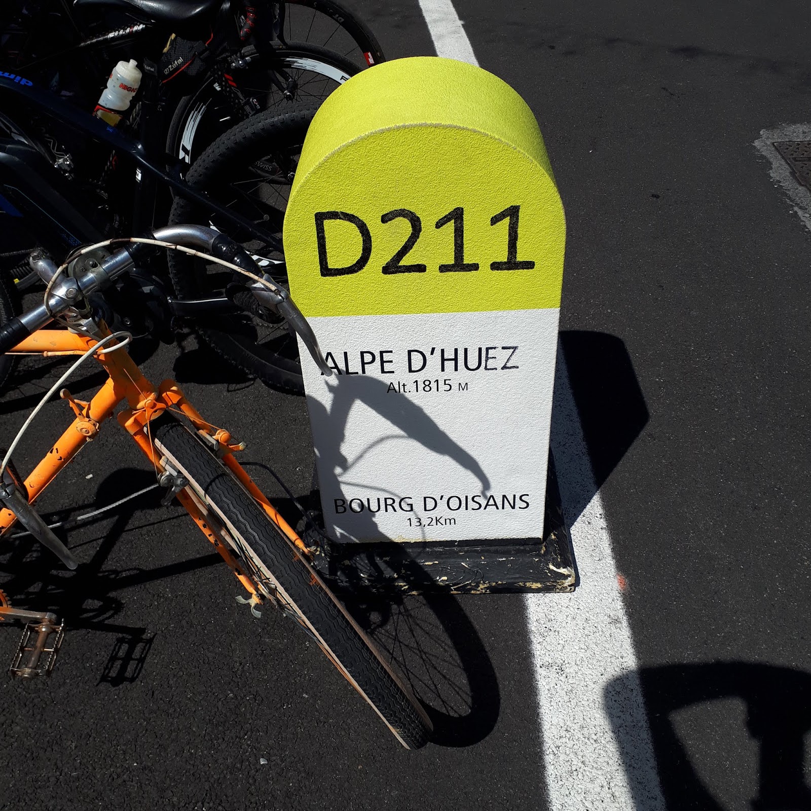
The climb is
very short compared to cols – only 13.2 km or 7.42 in pounds and it is over
before you know it. My ascent places me at 76500th or so out 81500 riders
on Strava! – Romain Bardet has the #1 spot. On the descent, I am 30000th
out 38500. So, as well as meaning that I descend better than I ascend, that
stat shows there are over 40000 riders that never came back!
This ride took
place at the autumnal end of August and I was lucky with the weather in that it
didn’t rain, though the first climb was through mist. It was a wee bit nippy at
night. This time of year has it’s good and bad points. Accommodation –
including camping - is more available, less congested and cheaper. Campsites
are usually quiet either side of peak season as the kids are back at school. The
roads are not packed with caravans and motorhomes. It is not unbearably hot.
But, if there are cons, the weather is unsettled, some bars and restaurants close
to take a breather before the ski season, so evenings can be a bit eerie as the
shutters slam down. It is also gets darker earlier – especially in shady
corners of steep-sided valleys.


I took a few
trains, as mentioned. https://www.oui.sncf is
a good place to start with regards to French trains but the process of finding
TGVs with bike spaces is a bit clunky. SNCF no longer have a UK site so there
is no telephone option other that calling France. The SNCF site has train and
timetable information – train services are identified by a number. Other
regional and local (Intercites and Ter) trains are simply turn up and go with
no need for reservations. The Ter are the best equipped for bicycles while the Intercites
are awkward to get aboard. Remember to vaildate your ticket in the yellow machines before boarding.


